PS-InSAR project
Il progetto PS-InSAR, rilasciato nel corso del 2019, si occupa della fruizione e della pubblicazione via web dei dati di interferometria.
È integrata la possiblità di visualizzare la serie storica in un unico ambiente, insieme ai dati geologici, alle informazioni derivanti dalla geologia applicata e ai dati del catasto dissesti regionale.
L'accesso alle informazioni è riservato e avviene in 3 modalità differenti:
Descrizione:
Grazie ad un accordo stipulato dalla Regione Valle d'Aosta con il Dipartimento di Scienze della Terra dell'Università degli Studi di Firenze (DST-UNIFI), la struttura regionale competente in materia (Attività Geologiche del Dipartimento programmazione, risorse idriche e territorio della Regione Autonoma Valle d'Aosta) riceve ogni 15 gg dati elaborati ed interpretati, derivanti da un monitoraggio in continuo delle deformazioni del terreno del territorio regionale valdostano tramite i dati radar interferometrici satellitari.
Il progetto prevede:
- L'attuazione di un piano di intervento per la fruizione via web dei dati di interferometria.
- La pubblicazione sul web di un servizio mappa basato su un database che contiene la serie storica dei dati interferometrici.
- L'implementazione di strumenti informatici per la consultazione dei dati interferometrici, integrata nel portale della Geologia.
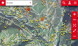
- I dati sono visualizzati utilizzando una specifica scala colori, classificati secondo la velocità annua di deformazione (espressa in mm/anno) secondo tale convenzione.
- Lo sviluppo di un modulo integrabile e fruibile in QGIS, per l'aggiornamento continuo del dataset.
Copertura: Regionale (3262 km²)
Accesso: Riservato e gratuito
E' possibile presentare una richiesta formale di accesso ai dati riservati alla struttura "Attività geologiche" dell′Assessorato Finanze, Innovazione, Opere pubbliche e Territorio, sito in località Amérique, 33 – 11020 QUART (AO). La messa a disposizione dei metadati e l′uso degli stessi potrà avvenire solo per attività "pubbliche" e, comunque, l'Amministrazione regionale si riserva la facoltà di non accogliere la richiesta.
Si ricorda che l′Amministrazione Regionale non è in alcun modo responsabile di qualsiasi interpretazione che verrà tratta dall′uso del dato PsInSARTM e SqueeSARTM.
Documentazione:
